 Catalogue PIGMA
Atmospheric conditions
Type of resources
Topics
Keywords
Contact for the resource
Provided by
Years
Formats
Representation types
Update frequencies
status
-
The CORE-II simulations provide a framework to evaluate ocean model performance, to study mechanisms of ocean phenomena and their variability from seasonal to decadal timescales, to identify forced variability changes, and to develop mechanistic descriptions of observed climate variability and change.
-
Today's normative and regulatory requirements to assess the producible energy from wind rely on in situ measurements (mast with anemometric sensors), which are extremely costly to Implement offshore. However, proof should be provided that hindcast model results are highly reliable, in order to provide an equivalent assessment. Very high resolution models is also the key issue in decision making for a proper siting that is relaying on the consistency of all datasets provided in the assessment. In this tender the products of the FP7 MARINA project will be used. 10-year (2001-2010) highresolution atmospheric, wave, tidal and ocean current simulations will be used. The model outputs are at high resolution (0.05x0.05 degree horizontal resolution, 1-hour time resolution, 5-vertical levels at 10,40,80,120,180 m). The wave parameters are co-located with the meteorological output fields. Satellite altimetry data from ENVISAT and JASON satellites have been assimilated in the system. Other wind and wave satellite data sets will be also analyzed (Synthetic Aperture Radars-SAR for example). At the same co-located points the tidal and ocean current data together with bathymetry are available. For preselected points in the North Western Mediterranean (Spain-France-ltaly areas) directional wave spectra data have been saved and are available. From SKIRON meteorological model available parameters are: WIND SPEED (m/s), WIND DIRECTION (deg), AIR PRESSURE (hPa), AIR DENSITY (Kgr/m3), TEMPERATURE (K), MODEL SEAMASK From the wave model available parameters: SIGNIFICANT WAVE HEIGHT (m), MEAN WAVE DIRECTION (deg), WAVE MEAN PERIOD (s), PEAK WAVE PRERIOD (s), SWELL WAVE HEIGHT (m), MEAN SWELL PERIOD (s), MEAN DIRECTIONAL SPREAD, WINDSEA MEAN DIRECTIONAL SPREAD, SWELL MEAN DIRECTIONAL SPREAD, MAXIMUM WAVE HEIGHT (m)
-
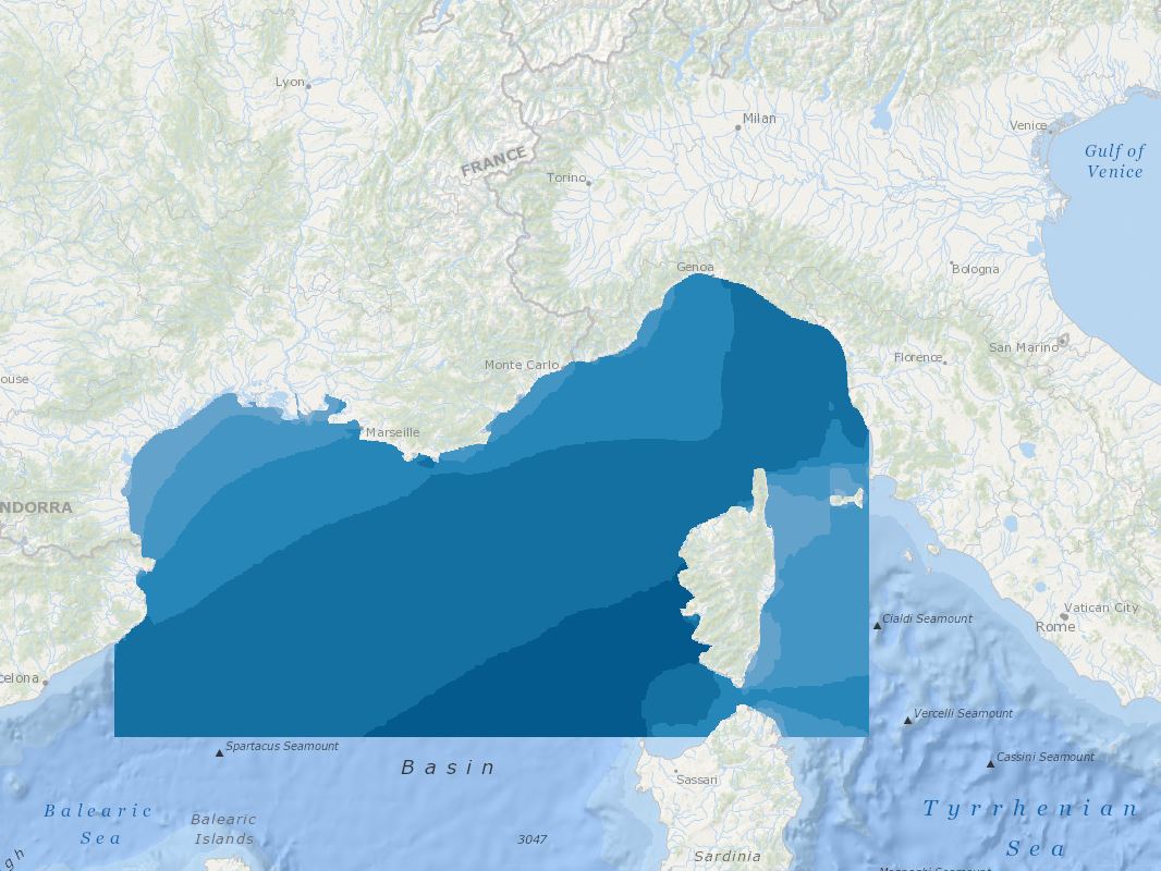
The Task Force on Hemispheric Transport of Air Pollution (TF HTAP) is an international scientific cooperative effort to improve the understanding of the intercontinental transport of air pollution across the Northern Hemisphere. TF HTAP was organized in 2005 under the auspices of the UNECE Convention on Long-range Transboundary Air Pollution (LRTAP Convention) and reports to the Convention’s EMEP Steering Body. However, participation is open to all interested experts, both inside and outside the UNECE region. TF HTAP organizes scientific cooperation in the areas of emissions inventories and projections, analysis of ambient monitoring and remote sensing, global and regional modeling, and impact assessment to understand the intercontinental flows of ozone and its precursors, fine particles and their components, mercury, and persistent organic pollutants (POPs). The main questions of interest to the TF HTAP relate to the benefits of international cooperation to decrease air pollution emissions: - How do air pollution concentrations (or deposition) in one region of the world change as emissions change in other regions or the world? - How do changes in emissions outside a region affect the health, ecosystem, and climate impacts of air pollution within a given region? - How does the feasibility of further emissions control differ in different regions of the world?
-

Several climate indices, regarding Atlantic Basin: - North Atlantic Oscillation - Southern Oscillation Index - Bivariate ENSO Timeseries - Tropical Northern Atlantic Index - Tropical Southern Atlantic Index - Oceanic Niño Index - Multivariate ENSO Index (MEI V2) - North Tropical Atlantic SST Index - ENSO precipitation index - Northeast Brazil Rainfall Anomaly - Solar Flux (10.7cm) - Global Mean Lan/Ocean Temperature
-
-
-

Data and imagery from the Atlantic basin: - Climate - Cloud Profiling Radars - Air-Sea & Air-Land Fluxes - Wind Profiling Radars - Satellite - Local Weather and Climate PSL archives a wide range of data ranging from gridded climate datasets extending hundreds of years to real-time wind profiler data at a single location. The data or products derived from this data, organized by type, are available to scientists and the general public at the links in the website. The third-party data appearing on this web site may be reformatted from their original form, but not altered as to the informational content contained therein. It is provided as a public service. Further, this data does not reflect an official view or position of NOAA.
-

The Ocean Colour Climate Change Initiative project aims to: Develop and validate algorithms to meet the Ocean Colour GCOS ECV requirements for consistent, stable, error-characterized global satellite data products from multi-sensor data archives. Produce and validate, within an R&D context, the most complete and consistent possible time series of multi-sensor global satellite data products for climate research and modelling. Optimize the impact of MERIS data on climate data records. Generate complete specifications for an operational production system. Strengthen inter-disciplinary cooperation between international Earth observation, climate research and modelling communities, in pursuit of scientific excellence. The ESA OC CCI project is following a data reprocessing paradigm of regular re-processings utilising on-going research and developments in atmospheric correction, in-water algorithms, data merging techniques and bias correction. This requires flexibility and rapid turn-around of processing of extensive ocean colour datasets from a number of ESA and NASA missions to both trial new algorithms and methods and undertake the complete data set production. Read more about the Ocean Colour project on ESA's project website. https://climate.esa.int/en/projects/ocean-colour/.